
Adapted from a feature that first appeared in November 2025 on Londonist: Time Machine, our much-praised history newsletter. To be the first to read new history features like this, sign up for free here.
How colouring in a 280-year-old map helped me to rediscover a lost London island.
Regular readers will know that I’ve been beavering away on a project to colour in a map of Georgian London. John Rocque’s 1746 chart is a masterpiece of cartography, in which the city is surveyed in unprecedented detail. Colouring this in is a heck of a job. Each of the 24 panels takes me about 20 to 30 hours.
I’m often asked if I do it with crayons or paint. Afraid not. It’s all digital. I use Photoshop to meticulously colour each building, field, river or tree. It’s much simpler this way. Each high-resolution panel is around 50cm x 70cm. I don’t have the means to print this out, nor scan it back in again afterwards. Plus, one of the kids would undoubtedly spill milkshake all over it.
There’s a third reason. Painting digitally lets me pull some clever manoeuvres that wouldn’t be possible with a scanned, flat image. Here’s a good example…
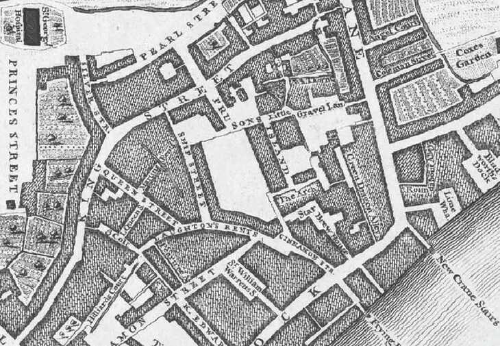
I’d like to focus on this riverside area, where Wapping merges into Shadwell. Here’s how it looks on the Layers of London website, uncoloured.
Now, look to the centre of the image, in the network of streets bounded by the lopsided-underpants shape. Here, you’ll find a dog-leg road labelled as PRUSONS ISLAND. See it? I was immediately intrigued by the name.
From the black and white image, Prusons Island does not seem to be an island. Nor can I find any other historical map that shows the area surrounded by water. Adrian Prockter of Know Your London has a fascinating article about the history of Prusons Island, but he was unable to find any evidence for its actual islandhood.
Now let’s see what happens when we add some colour to the John Rocque map:
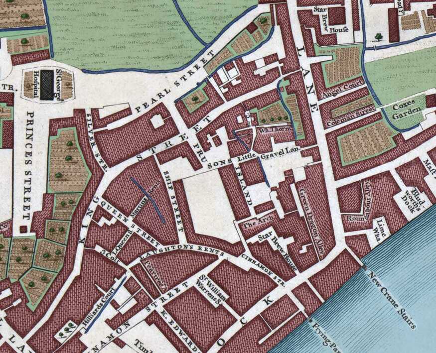
With the shading, we can now see that the district is crossed by a series of water channels (blue lines). The street labelled Prusons Island lies between two small waterways running roughly NW to SE, while a further trickles laterally above Pearl Street (top left). These are strong hints that Prusons Island might indeed have been surrounded by water at some point before 1746.
The advantage of using Photoshop is that I can build up my colours on different layers. So, for example, I use one layer for buildings (red), another for cultivated land (light brown), and another for waterways (blue). I can then switch individual layers on and off as the whim takes me. Here, then, is the view with all layers turned off except for water, and with its opacity turned up to 100.
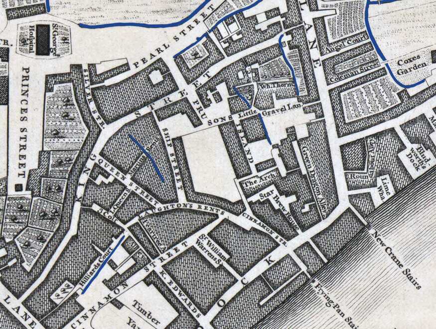
That makes things even clearer, and we can now see another water channel to the bottom-left, below Hilliards Court.
In truth, this isn’t particularly surprising. This part of Shadwell is very low-lying, and would have been marshy for most of its history. Those rivulets are the last remnants of the ancient landscape. However, their particular placement gives us confidence that Prusons Island might indeed once have been an island.
If you’ll allow me to now move into full-on speculative mode, I reckon we can reconstruct the full paths of those lost streams to create that island. Look at the curve of Laughtons Rents at centre-bottom. The most likely explanation for its shape is that it was built to follow the bank of the old stream, which is now buried. Let’s extrapolate the likely course, and also plug in the Hilliards Court remnant as a tributary:
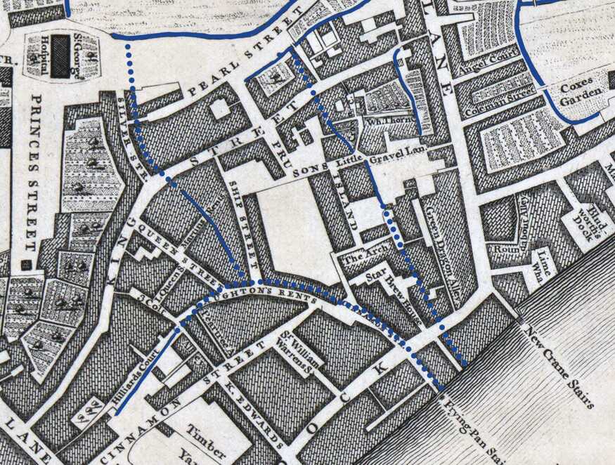
The dotted lines show my best guess as to where the streams extended, based on the curves in the street plan. Such a scheme would make an island of Prusons Island.
Now, here’s the fun bit. We can go back to the Layers of London map and get it to display parish boundaries (which are approximate):
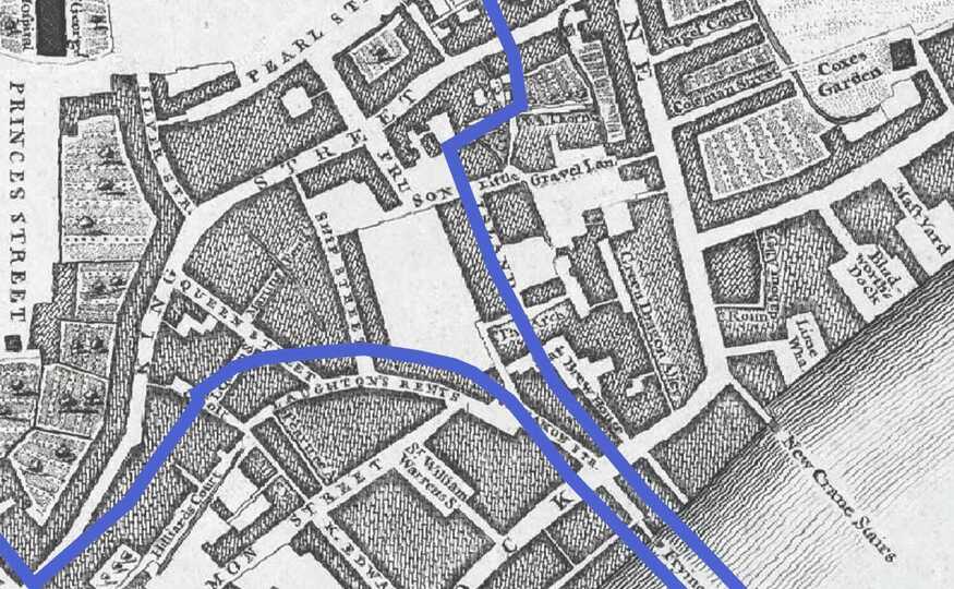
Would you look at that. The parish boundaries closely follow the curves of the roads, which (I reckon, based on remnants in the Rocque map) follow the course of ancient streams.
It is common for frontiers to follow natural features like waterways. The River Lea in east London, for example, was the ancient boundary between Wessex and the Danelaw, and later between Middlesex and Essex. It continues to serve as a boundary between the London Boroughs of Tower Hamlets and Newham today.
I don’t know how the parish boundaries in Shadwell and Wapping were drawn up but, looking at these curves, I strongly suspect they followed along the lines of the old watercourses in the area. If so, it shows that Prusons Island would once have been an island, before the roads and buildings covered over most of the channels.
Of course, I could be wrong about this, and I’d love to hear from any local historians who know more about the terrain. But at the very least, this thought experiment shows that “colouring stuff in” can be a useful lead-generator for historical enquiries.
What was Prusons Island anyway?
Turns out, Prusons Island has a long and fascinating history, quite aside from whether it ever had aqueous boundaries. It’s attested back to at least the 17th century, taking a variety of names including Prusoms Island, Prusom Island, Spruson’s Island and Sprucers Island. Nobody knows where the first part of the name comes from, though theories include a ‘prison island’ (unlikely) or some kind of maritime connection to Prussia. Most likely, it comes from some forgotten landholder’s personal name.
Like much of Shadwell and Wapping, Prusons Island was a place that looked to the river and the sea. Local census and marriage records list occupations such as shipwright, sailmaker and mariner, but also cordwainer, tanner and blacksmith. In other words, this was a place of manual labour.
The area changed radically from the end of the 18th century. The creation of the London Docks in Wapping (completed 1805) and Shadwell Basin in the 1830s would turn this part of Shadwell into a de facto island, much bigger than the Georgian island we were speculating about above.
Victorian times would see the arrival of a sizeable gas works on the old ‘island’ site. At this point, the name Prusons Island was transferred from the street shown in the Rocque map to part of the old, curving Laughton’s Rents. Here it persisted into the 20th century, usually as Prusom Island. One short history from 100 years ago describes the place as a “once notorious criminal and dissolute slum”. It goes on:
“The streets of Prusom Island are narrow and winding, and are gashed by open spaces where are the ruinous foundations of demolished houses, now used as playgrounds by the children of Wapping. To reach the island, you must walk through lengths of depressing street chasms with twenty or thirty foot dock wall, blank and dreary, on each side You will probably be held up at one or two swivel bridges while fussing tugs with interminable strings of barges drift dreamily by.”
The same article notes that Prusom island sits in a timewarp; its 2,600 inhabitants, mostly working class, are families who’ve been here for generations.
“They trace their residence there back for over a hundred years and boast that every family is pure English — a notable boast for a district set in a quarter inhabited by thousands of foreigners.”
It couldn’t last. A major rebuilding programme was afoot. Hundreds of tumbledown houses were demolished and replaced with housing blocks. Many families moved away during the upheavals. The Blitz, a decade or so later, would see off many more. New blocks were put up but, by then, the monoculture had dissolved.
Come the late 1980s and Wapping, like much of the former Docklands, was again under development. The Prusom’s Island site was not exempt. New housing replaced the surviving old blocks. Adverts from 1988 describe it as “Docklands’ newest prestige address,” which must have made the few surviving old-timers chuckle.
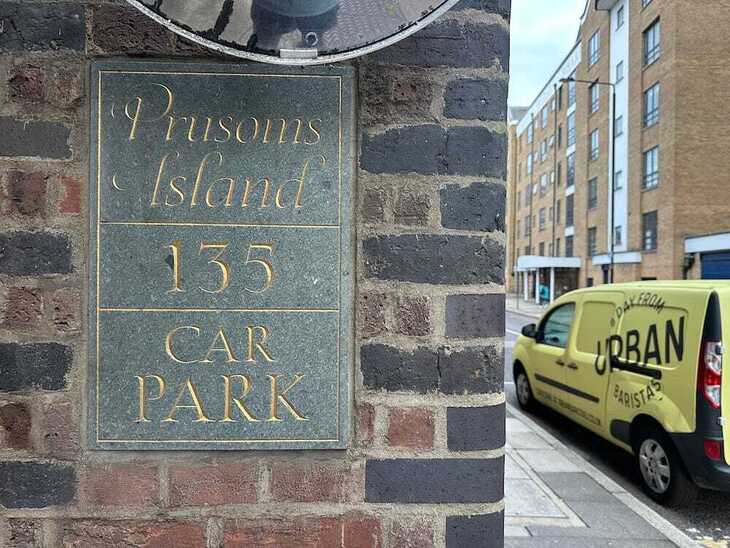
Today, the place would be unrecognisable to those who toiled here in the 18th and 19th century — but then this is true of many places. The name does, however, live on. The road labelled as King Street on the Rocque map still survives and is today known as Prusom Street. And if you look carefully at one of the old warehouse buildings, where Wapping High Street meets Hilliards Court, then you’ll see that a few dozen people still live in Prusoms Island.